

JERSEY SHORE – There is plenty of excitement in the air, maybe even a little dread regarding the forthcoming winter storm but will there be snow in the air and if so how much and what areas will get the most accumulation?
Even as local forecasters revise their models and update forecasts on a regular basis, the consensus seems to be that a winter storm is coming and will reach the Jersey shore by Monday morning. The storm is predicted to start Sunday night.
Currently we’re feeling the cold with communities in the northern portion of the state feeling the chill a bit more. The snow will start dropping around midnight on Sunday. The heaviest snow will be experienced around Monday morning into the afternoon which could play havoc on travel.
Forecasters are looking closely at the rain/snow line which could alter snow accumulation rates in areas. Many areas right now are in the six to 12 inch range in the state.
Toms River and areas of Ocean County may get less than originally predicted according to the National Weather Service going from six to eight inches to three to four inches.
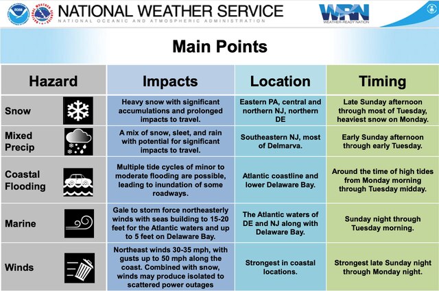
That change however may bring about coastal flooding even as northern and cenral portions of the Garden State are bracing for a snowfall higher than originally expected.
According to the National Weather Sevice, ranges of eight to 12 inches of snow jumped to 12 to 18 for Middlesex, Mercer, Morris counties and even Monmouth County. Early projections of six to eight inches of snow in Sussex and Warren counties have also increased to eight to 12 inches in those counties.
The good news for south jersey residents is that snowfall predictions have decreased there. Instead residents in the Vineland area of Cumberland County will be hit with snow, sleet and rain. The predicted snowfall dropped from six to eight inches to six inches.
Strong wind gusts are expected which could cause power outages which were experienced in some areas on Friday. The wind gusts could reach 40 to 50 miles per hour near the coast and over water. Gusts of 35-45 miles per hour could be experienced inland and could cause problems with visibility and snow drifts.
The National Weather Service has moved the Winter Storm Watch to a Winter Storm Warning and has warned travelers that road contions will most likely be difficult early Monday morning.


