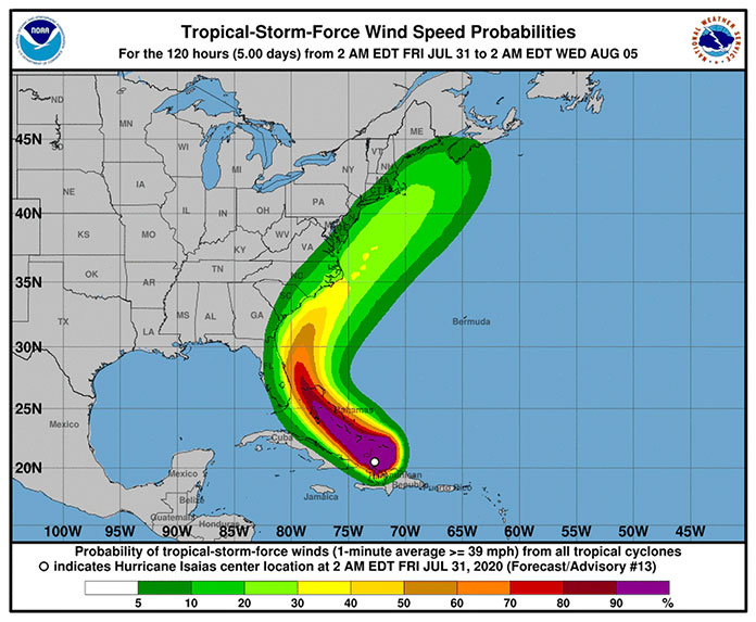
JERSEY SHORE – While Florida battens down the hatches, forecasters put out a warning that Tropical Storm Isaias might climb up the east coast, making it all the way to Maine by Wednesday.
The National Hurricane Center is tracking Isaias’ progress through the islands right now, predicting heavy rains, flash flooding, and other life-threatening conditions for the Bahamas, Dominican Republic, and other areas. A hurricane warning is in effect in those areas. The islands are expected to get sustained (one minute average) winds of 39 mph or greater.
The east coast of Florida should be prepared for tropical storm conditions, and even hurricane conditions, they said.
Officials said that the Carolinas should expect some minor flooding in the beginning of next week. Everyone along the east coast should monitor the storm’s progress, forecasters said.
According to the most recent maps, the storm should be going past New Jersey between Tuesday and Wednesday.
“NOAA’s analysis of current and seasonal atmospheric conditions reveals a recipe for an active Atlantic hurricane season this year,” said Neil Jacobs, acting NOAA administrator. “Our skilled forecasters, coupled with upgrades to our computer models and observing technologies, will provide accurate and timely forecasts to protect life and property.”
The Atlantic hurricane season lasts from June 1st to Nov. 30. New Jersey’s tropical storm activity occurs between August and late October. Sandy pummeled New Jersey on Oct. 30, 2012.
Warmer than usual sea surface temperatures in the tropical Atlantic Ocean and Caribbean Sea, reduced vertical wind shear, weaker tropical Atlantic trade winds and an enhanced west African monsoon season all increase the chances of an above-normal 2020 hurricane season.


