

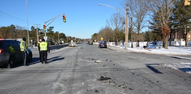
MANCHESTER – The township has seen a number of crashes in the area of Colonial Drive lately. One crash closed the road and delayed a Township Council meeting, and wrecked an electronic sign.
Colonial is a relatively short road, but it gets busy when it connects with Route 37, near town hall, the library, and the high school. Local officers did their own study of the area, Lt. Antonio Ellis told The Manchester Times.
The data showed that while it seemed like there were frequent crashes at that intersection, the information shows that it is not that high historically.
Traffic Safety Officer I Patrolman Michael O’Hara said he looked at the past three years of crash data from January 1, 2019 to January 10, 2022. During that time period, Manchester Township Police investigated approximately 2,900 crashes. Only eight of those crashes involved a vehicle travelling west on Route 37 with the traffic signal acting as a traffic control device.
“Only two crashes occurred within the last year,” O’Hara added. He noted that two recent crashes were caused by drivers, “following too closely and driver inattention.”

He added, those reasons “were the primary contributing factors for all of the eight crashes. Five of the eight crashes involved injuries which were predominantly minor in nature. There were no fatalities and only one of the eight crashes caused property damage.”
Patrolman O’Hara said that by utilizing crash data he was able to determine that the low amount of crashes makes it hard to recommend changes to the roadway or the traffic signal.
“Additionally, it shows that when crashes did occur, the individual operator made an error, specifically not providing their vehicle enough space to safely stop or being inattentive while operating a vehicle,” he said. “The timing of the traffic signal or the amount of time an individual was able to observe the traffic signal were not factors. I also went out to the location and did an approximation for how far away an individual would be able to observe the traffic signal.”
Using Google Maps as a measuring tool, the patrolman said a driver would have approximately .242 of a mile, or 1,277 feet, from the time of seeing the traffic signal until reaching the traffic signal stop line. “I utilized the time and distance equation to determine how much distance a vehicle would need to stop safely for the traffic signal.”
The officer analyzed factors of speed a vehicle was traveling, the coefficient of friction on the roadway, and a constant that is derived from gravity.
“This is an accepted formula used by traffic reconstructionist and engineers. The speed I used was 50 miles per hour which is the current speed limit in that area,” O’Hara said. “I utilized .7 (dry roadway) and .4 (wet roadway) for the coefficients of friction based off of a typical asphalt roadway during dry and wet roadway conditions. The distance a vehicle needed to stop safely, traveling the speed limit, showed 119 feet for dry roadway conditions and 208 feet for wet roadway conditions.”
The patrolman concluded that this equation further proves that there is more than enough distance for an attentive driver to stop safely at the traffic signal and no modifications are needed. He also noted that Route 37 is controlled by the New Jersey Department of Transportation “and any modifications would need to be imposed by them.”
Lt. Ellis concurred with the patrolman’s findings. He told The Manchester Time, the end results are that although there were two recent high-profile crashes at that intersection, “the factors causing those crashes appeared to be driver inattention and disregard of a traffic signal and not sight distance or any engineering issues.”


