

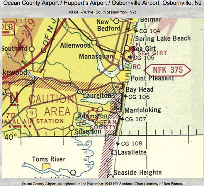
BRICK – The township was once home to a small airport off Drum Point Road that went by several names, including Ocean County Airport, Osbornville Airport, and Huppert Airport.
According to the website, “Abandoned and Little Known Airfields,” the airport was established at some point in 1942. A 1940s-50s advertisement for Huppert Aviation Company based at the airport offered “G.I. flight training,” passenger flights, charter service, sales and service, new and used panes for sale, plus aircraft and engine repairs.
“Learn to Fly!” the ad says. “You can complete a flight training course while on your vacation. Remember – if you can drive a car, you can fly Aeronca.”
Bruce W. Huppert had an Aeronca Aircraft dealership at the airport. Aeronca Aircraft Corporation was founded in 1928 and was the first company to build a commercially successful general aviation aircraft. When production ended in 1951, Aeronca had sold 17,408 aircraft in 55 models.
Brick Township historian Gene Donatiello, 81, said he remembers seeing airplanes take off from the airfield in the 1950s.
He said that Huppert, a native of Rochelle Park and a former barnstormer, production engineer for Bendix Aviation and flight instructor for the US Army Air Corps, purchased the airport from the Van Ness Corporation before moving to Brick in 1945.
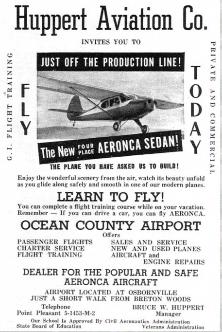
“Huppert, along with flight instructor Emil Repas, gave flying lessons using a single-engine 65 horsepower 1947 Aeronca aircraft, later adding a 285-horsepower Boeing to his fleet of planes,” Donatiello wrote.
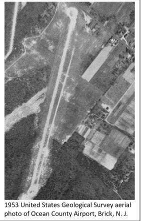
A 1953 U.S. Coast Guard map depicted Ocean County Airport as having two unpaved runways.
A 1958 sectional chart (a type of aeronautical chart designed for navigation under visual flight rules), showed that Ocean County Airport had a 2,750-foot-long turf and gravel runway. The airport had an elevation of 18 feet above sea level.
The airport was G.I. Bill-certified, and by April 1948, 60 G.I.s had entered pilot’s training at the airport and 20 received their private pilot’s licenses. The airport then had nine planes and was equipped for night flying, Donatiello said. (It was likely that runway lights were installed for nighttime landing.)
The “Abandoned and Little Known Airfields” site has a 1954 photo of the airport’s main hangar engulfed in a mass of flames. The fire destroyed the main hangar, 10 planes and a panel truck, and it was probably the beginning of the end for Huppert Aviation and Ocean County Airport.
In an Asbury Park Press article from Feb. 13, 1959, Bruce Huppert was quoted as saying that the airport would be closing and the land would be used for a housing development. The airport was no longer depicted in an April 1959 New York sectional chart.
In 1956, after the fire, Huppert was elected to a two-year term as Committeeman on the Brick Township Town Committee.
According to Donatiello, in November 1958, Huppert filed a map with the township subdividing the airport property into building lots that would become Sky Manor Estates.
In April 1959 he sold Section 1 to Accurate Construction Company, (which later became U.S. Home Corporation), and in August 1959, he sold off Section 2 to Development Corporation of America, Donatiello said.
Sky Manor was one of the first developments built after the Garden State Parkway opened for commuters.
In a nod to its past, Sky Manor has aviation-themed street names, such as Lockheed Road, Northrop Road, Boeing Drive, Pitcairn Road and Stinson Road.
In 1998, Brick Township, along with the Izaak Walton League, Ocean County Natural Lands Trust and the NJDEP Green Acres Program purchased from Joe Pal, Inc. and Topal Reality 24 lots creating what is now known as Brick Township’s Airport Tract, which is adjacent to the former airport.
The Airport Tract contains more than 285 acres of undeveloped lands, and is home to a variety of native, threatened and endangered species.
Despite its name, the Airport Tract was not part of the former airport, Donatiello said.


